24-Hour Street Design Can Leave Valuable Space for Other Uses
Most Managing Issues blogs deal with communication. We thought this take on designing streets for efficiency instead of peak use offered valuable insights into issue management.
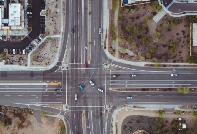
 Street planning isn’t a top-of-mind topic for most people. Since 80 percent of public space in most cities is under asphalt and divided into lanes, maybe we should pay more attention.
“Designing roads for peak-hour car traffic is like designing your dining room for Thanksgiving dinner.”
Kittelson & Associates, a Portland-based engineering firm, authored a report that challenges the long-time practice of designing streets based on peak-hour traffic. “Designing roads for peak-hour car traffic is like designing your dining room for Thanksgiving dinner – most evenings, you’ll be eating dinner surrounded by empty chairs,” according to NCHRP Report 1036, Roadway Cross-Section Reallocation: A Guide.
The report suggests as alternative, which it calls the 24-Hour Capacity Framework. “As an alternative to designing roads based on peak-hour capacity estimates, [the Framework] introduces an all-day perspective on corridor delay and travel time to help practitioners accurately measure demand and understand tradeoffs.”
In practice, this alternative approach means measuring street use for the 16-hour period from 5 am to 9 pm to determine when and for how long it operates at capacity and when it has excess capacity.
“These performance measures not only track how often a roadway operates under capacity, but also how far below capacity it is operating,” the report says. “This information is important for weighing tradeoffs and more closely evaluating scenarios at or below operational screening thresholds. This all-day evaluation can aid practitioners in assessing the impacts of design decisions beyond peak periods.”
The Problem with Oversized Streets
The report offers counter-intuitive points about oversized streets – they make walking and biking less safe; more travel lanes increase wait times; more lanes mean less space for other uses such as sidewalks, bike lanes, parks and housing.
In a web post describing the report, Kittelson provides an example of how an intersection could be analyzed with different options – a traffic signal and four lanes, a traffic signal with three lanes, a traffic signal with two lanes and a roundabout with one lane in each direction. The example shows the four-lane option outperforms the other options during a 7 am peak morning hour, but has excess capacity the rest of the day. The three-lane option is better at accommodating car traffic and leaving space for other modes. The two-lane option has the best overall 16-hour efficiency, while the three-lane and roundabout options have nearly double the efficiency of the four-lane option.
“Using this information, we can discern that the two-lane signal would result in significant delay for a significant portion of the day,” the report concludes. “However, both the three-lane and roundabout options offer satisfactory capacity 23 hours of the day, and generally offer much improved efficiency of the intersection.”
The report’s authors emphasize the point of their alternative analysis is to take a broader view of street design. “The evaluation of the roadway should take into account a more holistic and inclusive set of measures that includes delay and operations for people walking or biking, as well as safety considerations for all users.”
Conor Semler
Giving the Public Honest Choices
“The most important thing is not to change people’s minds, but to be honest about the choices on the table and describe them fairly,” says Conor Semler, a principal planner at Kittelson and the report’s principal author.
The Kittleson web post describing the alternative approach says, “The guide emphasizes the importance of context and community priorities when deciding which tradeoffs are acceptable and which are not. Multiple access points for businesses or uninterrupted sidewalks? Free flow for drivers or signalized crossings for pedestrians? Ample parking or protected bike lanes? Honest conversations need to happen early in the process to ensure that safety for all users is considered when designing a roadway’s cross-section and the resulting roadway cross-section reflects the community’s true desires.”
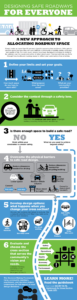
The post includes an infographic showing the recommended six-step process to allocate roadway space that places a high priority on safety and seeks to conform design with community vision.